Timber Soil Rating
A field study was started in 1947 on the relationship of soils, climate and timber site quality. This paper reports on studies of 163 filed locations extending from the Pacific Ocean to the east side of the Sierra Nevada mountains in Nevada. The soils were studied at each location, then classified, and the timber site-quality determined by referencing the height and age value to appropriate site class curves.
Four main soil factors appear to govern or limit the growth of conifers in California. These are A-Soil depth and texture characteristics; B-Soil permeability; C-Soil chemical characteristics; D-Drainage and runoff properties. In addition there is the climatic factor.
High sites for growing conifers in California need a deep soil of sufficiently fine textured to hold about 12% of more of moisture; a permeable profile; have no toxic chemical characteristics; be of acid reaction; well drained; and have a total annual rainfall of more than 40 inches.
A preliminary timber rating chart is presented in this paper based on assigning percentage ratings to five factors: A-Soil depth and texture; B-Soil permeability; C-Soil chemical characteristics; D-Drainage and runoff properties; E-Climate.
Four climatic zones are considered in rating the timber sites in the Sierra Nevada and Coast Range Mountains of California and Nevada.
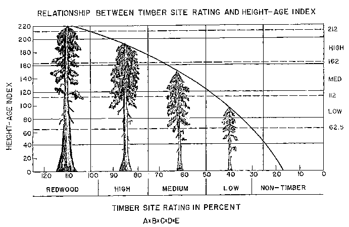
Timber Site Rating = A x B x C x D x E.
Timber Soil Rating Chart
An Index for Rating the Value of Soils for Growing Timber in California
Factor A: Depth-Texture 1/
|
Depth-Texture |
Rating in percent |
Depth class |
|---|---|---|
| Over 72" depth | 100 | 5 |
| 60-72 | 90-100 | 5 |
| 48-60 | 80-90 | 5 |
| 36-48 | 70-80 | 4 |
| 24-36 | 50-70 | 3 |
| 12-24 | 30-50 | 2 |
| 0-12 | 0-30 | 1 |
1/ No effect to rating for textures with 12% or more available water capacity.
Factor B: Permeability
|
Permeability |
Rating in percent | Profile Groups |
|---|---|---|
| Moderately rapid & rapidly permeable profiles | 100 | I; II; VII-I, II; VIII-I, II; IX-I, II |
| Moderately slow & slowly permeable profiles | 80-90 | III; III+; VII-III, III+; VIII-III, III+; IX-III, III |
| Very slowly permeable profile | 30-70 | IV; V; VII-IV; VIII-IV; IX-IV |
Factor C: Chemical (Alkalinity, Salinity, Etc.)
| Chemical effect | Rating in percent | Toxicity class |
|---|---|---|
| None | 100 | |
| Slight | 80-90 | S |
| Moderate | 20-80 | M |
| Strong | 0-20 | A |
Factor D: Drainage-Runoff
| Drainage | Rating in percent | Drainage symbol |
|---|---|---|
| Well & moderately well | 100 | w |
| Excessively | 80-95 | r |
| Somewhat poorly | 40-80 | i |
| Poorly and very poorly | 10-40 | p |
Factor E: Climate
| CF--Coastal Fog (Redwood) |
CR--Coastal Range (Douglas fir) |
WS--Westside Sierra (Pine) | ES--Eastside Sierra Pine (P.J.) | ||||
|---|---|---|---|---|---|---|---|
| Rainfall (in.) | Rating percent | Rainfall (in.) | Rating percent | Rainfall (in.) | Rating percent | Rainfall (in.) | Rating percent |
| 45 | 120 | 45 | 100 | 45 | 100 | 40 | 90 |
| 40 | 110 | 40 | 95 | 40 | 95 | 35 | 80 |
| 35 | 100 | 35 | 90 | 35 | 90 | 30 | 70 |
| 30 | 90 | 30 | 60-70 | 30 | 50-60 | 25 | 60 |
| 25 | 80 | 25 | 30 | 25 | 20 | 20 | 50 |
| 20 | 30 | 15 | 40 | ||||
Importance of Soil Classification and Rating of Soil for Timber Sites
The classification of soil together with a rating of soil for timber site quality will strengthen the California forest resources survey in two ways. First it will facilitate and improve the quality of the timber site classification. Previously this classification has been base entirely on the height-age relationship of dominant trees without reference to the soil. Ratings were satisfactorily made where dominants were present, as in the case of virgin timber or older second growth. On the other hand difficulties were encountered in making reliable ratings in many cut-over or burned-over areas where suitable dominants were infrequent or entirely absent. Also in some cases where timber growth was absent it could not be determined with any degree of certainty whether the sites were suitable at all for growing timber. In present forest resources survey these difficulties are overcome by rating timber sites from soil in areas lacking dominant trees. Second, the maps produced by the survey, since they show the location of good, fair, poor, and unsuitable sites for growing various kinds of timber trees, will have greater usefulness to those interested in managing forest lands for timber crops. To illustrate, a private enterprise seeking to purchase a forest property to provide a continuing supply of raw material for a lumber manufacturing or wood pulp plant can use the maps to locate he best soils for growing crops of the kind of timber it wants. Also public agencies interested in reforesting some of the 5 million acres of essentially unstocked and idle forestry sites in California can use the maps advantageously to plan and carry out planting programs. From the maps the best soils can be selected for high priority planting and the appropriate species for those soils can be determined.
Areas outside the boundary of the present forest resources survey can be more easily appraised from a knowledge of the soil and climatic factors in their relationship to the vegetation and land use problems. Thus a knowledge of the soils such as collected in the basic soil survey on agricultural lands can and should be extended to natural resources survey on the so called wild lands of the country because a knowledge of soils and climate is just as necessary to properly evaluate the productivity of land for timber crops as for agricultural crops.